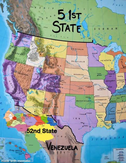
Washington: US President Donald Trump has triggered fresh international controversy after sharing an image of a modified map of the United States that appears to include Canada, Greenland and Venezuela as part of US territory. The image was posted on Trump’s social media platform, Truth Social, and quickly went viral, drawing sharp reactions from governments, political leaders and commentators across the world.
What the Map Shows
The image depicts a reimagined US map in which:
- Canada is merged with the United States to the north,
- Greenland, an autonomous territory of Denmark, is shown as a US-controlled region, and
- Venezuela appears integrated into the US landmass in the south.
While Trump did not explicitly state that the map represented official policy, the post was widely interpreted as provocative political messaging. Several media outlets and analysts noted that the image appeared to be digitally altered or AI-generated, rather than an official or factual geographic representation.
Trump Camp’s Position
Trump has not issued a detailed clarification following the post. However, allies close to him suggested the image should be seen as symbolic or rhetorical, reflecting his long-standing “America First” worldview rather than a literal territorial claim. In the past, Trump has spoken publicly about the strategic importance of Greenland and has taken a hardline stance toward Venezuela, particularly over oil resources and governance.
International Reactions
Canada:
Canadian political figures and media strongly criticised the image. Commentators described it as “absurd” and “disrespectful to sovereignty.” Prime Minister Justin Trudeau has previously dismissed any notion of Canada becoming part of the US, famously stating there is “no chance at all” of such a scenario.
Greenland and Denmark:
Leaders in Greenland and Denmark reacted with renewed emphasis on territorial sovereignty. Greenlandic officials reiterated that the island’s future would be decided solely by its people, while Danish leaders called the image “unacceptable” and contrary to international norms.
Venezuela:
In Caracas, pro-government voices condemned the map as evidence of “imperialist thinking.” Venezuelan media linked the image to long-running tensions with Washington over sanctions, oil policy and regime change allegations.
Europe and Global Community:
European Union officials and international analysts warned that such imagery, even if symbolic, can undermine diplomatic trust. Several commentators stressed that borders are protected under international law and should not be trivialised for political messaging.
Expert and Media Analysis
Foreign policy experts noted that while the image has no legal or diplomatic standing, it reflects a pattern of using provocative visuals to energise political bases and dominate global headlines. Analysts also warned that repeated use of altered maps or symbolic territorial claims can escalate misunderstandings at a time of already heightened geopolitical tension.
Conclusion
Trump’s sharing of the altered US map has reignited debate over political symbolism, sovereignty and the use of provocative imagery in global politics. While the post does not translate into official policy, the strong reactions from Canada, Denmark, Venezuela and other international actors underline how sensitive territorial issues remain on the world stage.